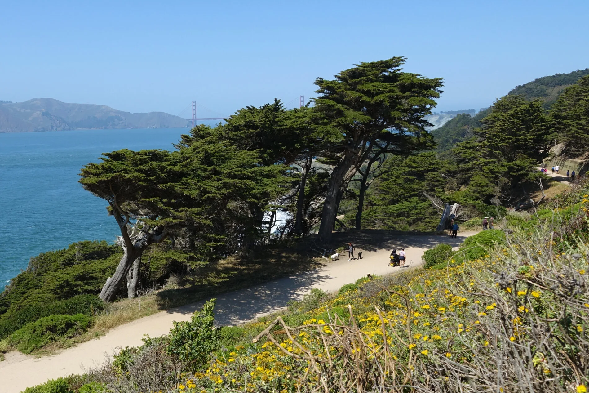
Take the San Francisco Lands End Hike, and discover gorgeous views of the rugged Pacific Coast and Golden Gate Bridge along the Lands End Trail.
The Lands End Hike has spectacular views of the rugged Pacific Coastline, the Golden Gate Bridge, windswept cypress trees, beaches, and wildflowers. It passes by the historic points of Sutro Baths, the USS San Francisco Memorial, and you might even see migrating whales. A short spur off the main Lands End Trail leads to scenic Mile Rock Beach.
The Lands End hike is my favorite, and I hope you take it and enjoy it too. For more things to see and do in San Francisco, check out our San Francisco Itinerary post, which has 1, 2, and 3-Day suggested itineraries and bonus lists of sights to help you create a custom itinerary.
For more urban trails with great views, see our Hiking in San Francisco post. For more trails along coastal bluffs, you might like the Monterey Ridge and Old Cove Landing trails in hikes in Santa Cruz.

This article has the following information about Lands End Trail:
- Trail at a glance and location
- Time and distance
- Link to our Google map with the trail plotted and landmarks and bus stops marked with pins
- How hard is the hike?
- Trail conditions
- Spur trail to Mile Rock Beach
- Parking at Lands End
- Getting there on Public Transit
- Important things to know (safety, bathrooms, bikes, dogs…)
- Lands End Lookout Visitor Center
- History and other details like why it’s called Lands End
Lands End Hike at a Glance
| Distance (1-way) | 1.5 miles |
| Difficulty | Easy to moderate |
| Accessible | Part way |
| Kids | Yes |
| Dogs (leashed) | Yes |
| Bikes | Part way |
| Food, water | Visitor Center only |
| Restrooms | Visitor Center only |
Location
Lands End Trail skirts around the outer perimeter of Lincoln Park on the western edge of San Francisco. In some places, the trial meanders through wooded areas and parts of it are right along the Pacific Ocean.
- Northeast Trailhead: begins at 32nd Avenue and El Camino Del Mar (where El Camino Del Mar enters Lincoln Park)
- Southwest Trailhead: begins at the Lands End Lookout Visitor Center (680 Point Lobos Avenue)

How Long Does it Take to Hike Lands End Trail?
Quick Answer
- 90 minutes one-way for the main 1.5 mile trail
- 30-45 minutes more if you also take the spur trail to Mile Rock Beach (it’s only 0.34 miles round trip, but it’s all stairs)
Not So Quick Answer
- The main Lands End Trail is 1.5 miles (2.4 km) one-way and takes about 90 minutes with stops to enjoy the views and take photos.
- The spur Mile Rock Beach trail is 0.34 miles (0.5 km) round trip from the main trail (allow 30-45 minutes round trip). Add more time if you want to linger at the beach. On my most recent trip to the beach, I hiked down in 14 minutes and back up in 21 minutes, but I was counting stair steps, taking notes and photos, and catching my breath.
- The Lands End Trail in one direction plus the round trip spur to Mile Rock Beach is 1.7 miles (2.7 km).
Lands End Trail Map

How Hard is the Lands End Hike?
The section between the Lands End Lookout Visitors Center and Mile Rock Overlook is an easy 0.5-mile (0.8 km) walk. Many people walk this wide, smooth, fully accessible section and then walk back — it’s like a promenade.
If you hike the entire main trail, some parts are moderate and even more so if you add the spur trail to Mile Rock Beach. One section of the main trail is stairs and all of the Mile Rock Beach spur trail is stairs.
This is a very popular hike and, especially on weekends, it can be quite busy. The trail is a favorite with people of all ages. You’ll see multigenerational families, people with children in strollers, and people with dogs (leashed, of course).

Land End Trail Conditions
The first half-mile, between the Visitor Center and Mile Rock Overlook, follows an abandoned railroad bed and is wide, smooth, mostly flat, and ADA accessible. Most of the rest of the trail is mixed. Some sections are wide and smooth, some are so rutted, or rocky, or narrow you may wonder if you’re still on the right trail.
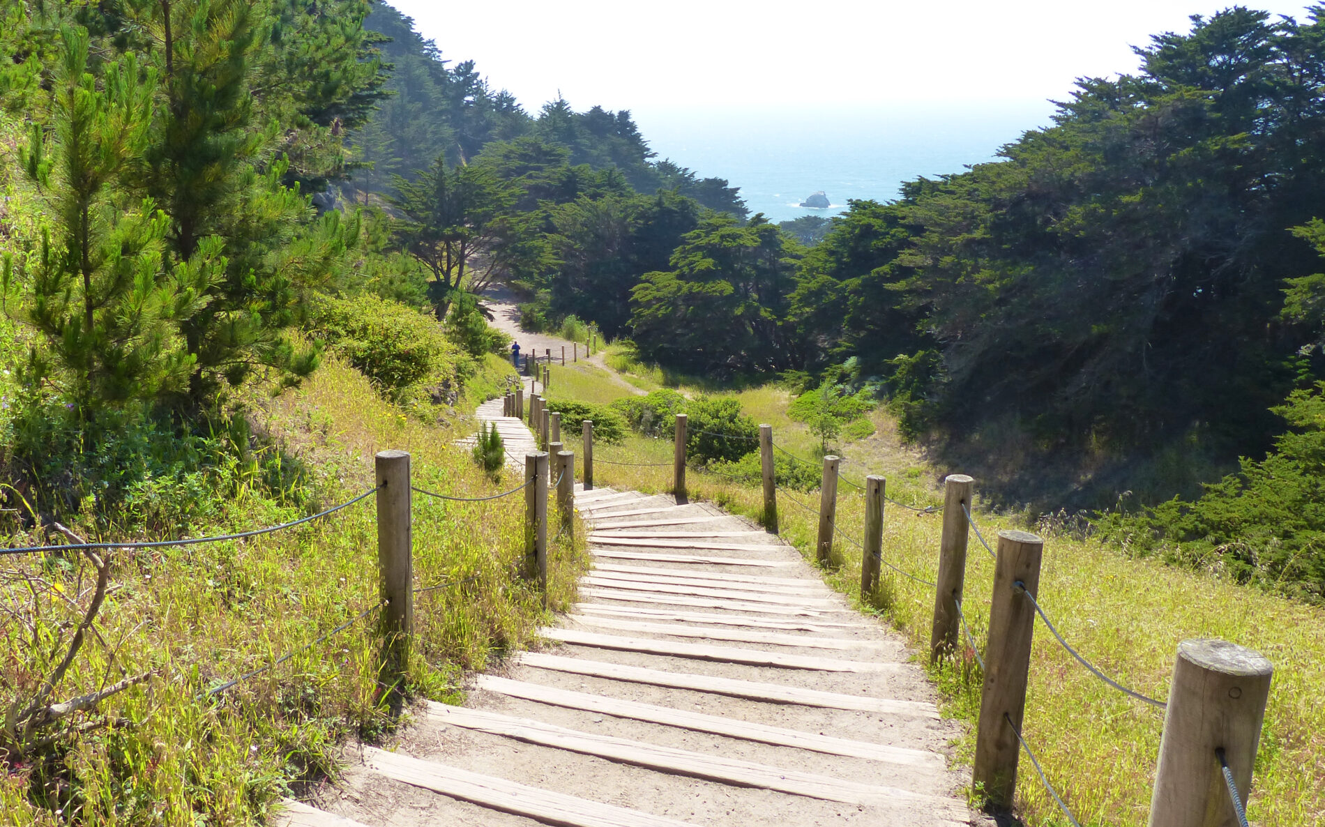
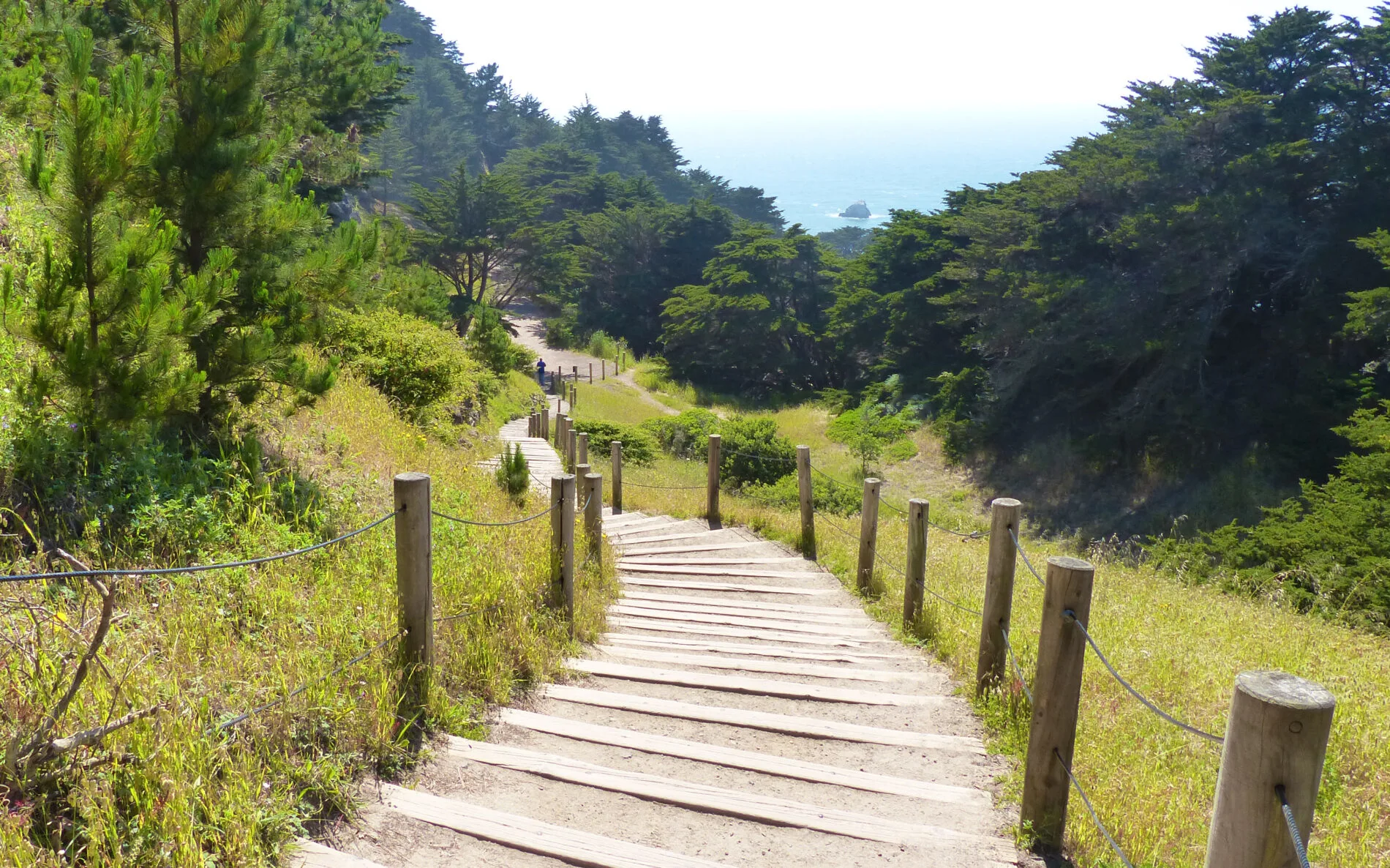
Depending on the season, it can be muddy or dusty. The section of trail between Eagles Point and Painted Rock has rustic stairs going up and down a small hill. There are 255 stair steps, but they are low rise and easy to walk.
The spur trail down to Mile Rock Beach is almost all stairs (250 steps — each way). Parts of the trail skirt around the bluffs overlooking the ocean, rocky cliffs, and the Golden Gate Bridge. Other parts of the trail meander through wooded areas with a variety trees, shrubs, grasses, and wildflowers.

Getting to Mile Rock Beach
The short but steep spur trail to Mile Rock Beach takes you through one of the most rugged and scenic parts of Lands End. The trail down to Mile Rock Beach also led to the location of the popular Labyrinth, but in 2021 the labyrinth was destroyed again and likely will not be rebuilt.
Mile Rock Beach
The trail branching off to Mile Rock Beach is marked with a sign. The trail is steep with rustic stairs all the way down. The low-rise, wide-tread steps are dirt with timber edges. They are easy to walk, but there are lots of them (about 250 stair steps in all). The round trip from the main trail to the beach is 0.34 miles (0.5 km).
Ways to Hike Lands End
There are lots of options for hiking the Lands End Trail: round trip, one-way, or just part of the trail. Here are three possibilities:
- Short and easy — Start at the southwestern end by the Lands End Lookout Visitor Center and walk the wide, smooth, mostly flat part of the trail to Mile Rock Lookout and then walk back. It’s 0.5 miles (0.8 km) each way, and it’s ADA accessible.
- One-way — Start at either end and walk the entire Lands End section of the Coastal Trail. It’s 1.5 miles (2.4 km). If you add the spur trail to Mile Rock Beach, add another 0.34 miles (0.5 km). The obvious complication with this one-way option is that you can’t easily drive and park. Taking public transit solves this issue.
- The whole loop — Start at either end, walk the entire trail, and walk back. Or, in one direction, take the shortcut through the golf course and the Legion of Honor. If you take the whole trail in both directions and add the Mile Rock Beach spur, the entire trek is 3.4 miles (5.5 km).
Is There Parking at Lands End?
Parking at Lands End is free, but the available lots can fill up early, especially on weekends:
- At the southwest end (Lands End Lookout Visitor Center) there are three lots: a big lot at the Visitor Center, a smaller lot on Point Lobos Avenue directly across from the Visitor Center, and the Fort Miley lot at the USS San Francisco Memorial (on El Camino Del Mar). All three lots are free, and they all limit parking to 4-hours between 7a and 6p. They all fill up early on the weekends, especially if the weather is nice.
- At the northeast end of the trail (El Camino Del Mar near 32nd Avenue) the only parking is on the neighborhood streets. Parking is not restricted (no meters, hour limits, or permit requirements), but it’s scarce.
Getting to Lands End on Public Transit
I prefer public transit because I like walking the trail one-way and don’t need to backtrack to get my car. I also like ending the trail at the southwest end, so I can stop by Cliff House and enjoy a pint of Anchor Steam and Crab Cake appetizer while watching the waves crash on Seal Rocks (it’s a tough assignment).
Alas, Cliff House closed in 2020, but rumor has it that it will reopen sometime in 2023.
Here are the public transit options. For details about fares and ways to pay, visit our related post: Getting around San Francisco on public transit, and see the bus stop locations pinned on the Google map above.
- Southwest Trailhead: To get to or from the Lands End Lookout Visitor Center (the southwest end of the Lands End Trail, take the 38R Geary bus. It goes from the SF (downtown) Transit Center, travels along Market Street and Geary Boulevard to 48thand Point Lobos Avenues.
Tip: The R in 38R stands for Rapid. This bus makes limited stops along Geary. You can also take the regular 38 Geary bus, but not all 38 Geary buses go all the way to 48th Avenue.
- Northeast Trailhead: To get to or from the northeast end of the trail (where El Camino Del Mar enters Lincoln Park), take a 1 California bus from downtown to 32nd Avenue at California. Walk north on 32nd Avenue to El Camino Del Mar and turn left. The trail sign is directly ahead.
- Northeast Trailhead Alternate Route (from the 32nd Avenue at California bus stop): Walk one block west on California, where it dead-ends into the beautiful tiled Lincoln Park Stairs. Take the stairs and turn right onto the dirt path. The path ends where El Camino Del Mar enters Lincoln Park. The path follows the edge of the 18th Fairway on Lincoln Park Golf Course, so if you hear someone yell “fore,” duck and cover your head.

Important Things to Know
- NO Bathrooms or food, or water along the trail. The only bathrooms are at the Lands End Lookout Visitor Center at the trail’s southwestern end. The restrooms are open from 9a-5:30p on Monday through Friday and 9a-7:30p on Saturday and Sunday.
- Stay on the marked trails. Side trails along the cliffs are dangerous.
- Bring a sweatshirt or jacket. If the fog rolls in, it’s gets really chilly, really fast.
- ADA Accessible: The trail section between the Lands End Lookout Visitor Center and the Mile Rock Overlook is ADA accessible. This trail section follows the roadbed built for the long gone Ferries & Cliff House Railroad, so it’s wide, smooth, and mostly flat.
- Bikes are not allowed on the section between the Mile Rock Beach spur trail and Eagles Point. The trail is not well suited for them, because it’s narrow in places and there are lots of stairs.
- Watch out for poison oak. Learn to recognize it with this Golden Gate National Parks Four-Season Field Guide to Poison Oak.
- Dogs love the Lands End trail (on a leash).
- Watch out for coyotes.

Why is This Location Called Lands End?
The location of the trail is called Lands End because it was literally the end of the road. It was the westernmost end of Lincoln Highway, which was America’s first cross-country highway. It was completed in 1913 and went from New York’s Times Square to San Francisco. It ended in the northwest part of the city where Lincoln Park is now.

Is Lands End a National Park, a City Park, or Coastal Trail?
Lands End is all of the above and more. It’s part of all of these:
- Golden Gate National Recreation Area (GGNR) is a very unique National Park. It’s unique because it’s a collection of scattered sites along the San Francisco Bay Area coast including Alcatraz, Muir Woods, and the Presidio. It’s also unique because — except for Alcatraz and Muir Woods — all of the GGNR sites are free to enter.
- California Coastal Trail is a network of trails following the state’s 1,200-mile Pacific Coast shoreline. Lands End Trail is the Coastal Trail section between the Lands End Lookout Visitor Center (by Cliff House and the Sutro Bath ruins) and where the Coastal Trail and El Camino Del Mar enter Lincoln Park (near 32ndAvenue).
- Lincoln Park is a 100-acre park located in the northwest part of San Francisco and is also home to the Palace of the Legion of Honor — a fine arts museum, a Holocaust Memorial, and an 18-hole public golf course. The Lands End Trail skirts around the outer perimeter of the park between the cliffs, the golf course, and Fort Miley.
- UNESCO Golden Gate Biosphere Reserve created by UNESCO to promote cooperation between various groups responsible for managing sensitive protected areas.

Stop by the Lands End Lookout Visitor Center
By all means stop by the Lands End Lookout Visitor Center. It, thankfully, has nice restrooms, but that’s not all. It has interpretive displays about the history and culture of Lands End, gifts and souvenirs, and a cafe.

The Visitor Center also sells a selection of books, brochures, sweatshirts, souvenirs, and more. The friendly staff will answer questions and offer a free and informative National Park Service map of the trail and area.
The café has drinks, snacks, and very good sandwiches. They pre-make sandwiches for the days rush and have them neatly wrapped in brown paper. I get the Turkey with Avocado on Ciabatta Bread and tuck it in my day trip backpack.

Bits of Lands End History
USS San Francisco Memorial
The heavy cruiser USS San Francisco had a major role in the November 1942 Battle of Guadalcanal where the ship suffered major damage and 107 crew members lost their lives. The Memorial is just above the Lands End Trail and is connected to the trail with a flight of stairs (55 steps). There are great views from the Memorial, free 4-hour parking in the adjacent Fort Miley parking lot, and two (lightly maintained) porta-potties.

Sutro Bath Ruins
Adolph Sutro was a man of many talents. He was a successful engineer, a land developer, and, from 1895 to 1897, was Mayor of San Francisco. He built the Sutro Baths between 1892 and 1896.
The 3-acre complex included seven pools (cleverly filled by high tides), changing rooms, restaurants, a bandstand, and more. It was a recreational complex for San Franciscans and thousands flocked to it, but it was never a financial success and closed in 1964.
The complex burned to the ground 1966, while being demolished. All that remains now are parts of the foundation.
Cliff House
Cliff House was originally built in 1858 and has been rebuilt four times. In 1896, Adolph Sutro built the third and most striking incarnation of Cliff House. It was a stunning seven-story Victorian Chateau, which survived the 1906 earthquake and burned to the ground in 1907. It was rebuilt twice more.
Today, it’s part of the Golden Gate National Recreation Area, which is a National Park. The very successful restaurant and bar complex is operated by a concessionaire for the National Park Service. It has very good food and service and great views overlooking Seal Rocks. NOTE: Cliff House is currently closed but, hopefully, will reopen in 2023.
Steam Train to Sutro Baths and Cliff House
The Ferries & Cliff House Railroad ran small steam trains from downtown to the cliffs from 1888 to 1905. Adolf Sutro, who owned and developed the surrounding land, built the railroad to ferry people from downtown to the Sutro Baths, Cliff House, and Ocean Beach. The railroad was plagued with landslides, but the views on the 2-mile section, which ran along the cliffs, would have been spectacular.
In 1905, the railroad replaced the steam trains with electric streetcars. They ran until 1925 when heavy rains washed sections of the track into the ocean. Parts of Lands End Trail are on the remaining railroad bed.
Shipwrecks
The entrance to the Golden Gate is stunning, but before modern navigation tools were invented the entrance was treacherous. Dense fog, swift currents, and rocks caused many shipwrecks. Over 300 vessels have sunk trying to enter or leave the Golden Gate.
Three shipwrecks still have parts visible at Lands End during extreme low tides: the Lyman A. Stewart, the Ohioan, and the Frank H. Buck. All three ships met their end during heavy fog:
- The oil tanker Lyman A. Stewart sank in 1922 after departing the Golden Gate with a full load of oil. In the dense fog, the Stewart collided with another ship. Badly damaged and taking on water, the captain had the crew abandon ship and he stirred it toward Lands End. It crashed on the rocks near Mile Rock Beach.
- The cargo ship Ohioan sank in 1936 when, lost in dense fog, the captain mistakenly stirred the ship between Seal Rocks and Sutro Baths and crashed on the rocks next to Point Lobos. All that’s visible today is the ship’s boilers.
- The Frank H. Buck was also an oil tanker and was the sister ship of the Stewart. It sank in 1937 following a collision with a passenger ship unseen in the fog. The crew managed to ground the ship off Lands End where it came to rest across the stern of its sister ship, the Stewart, which sank in 1922. The engine blocks are all that remain of the two ships.
Conclusion
San Francisco is very compact and densely populated, so having lots of parks, gardens, and trails are an essential ingredient in making the city more livable. Fortunately there are several trails in the city.
Our Hiking in San Francisco post has brief details about our favorite hikes. We also have separate posts for each hike with a map, photos, and more detailed information:
- Golden Gate Promenade: Waterfront Trail, Best Views
- Barbary Coast Trail: Self-Guided Walking Tour
- Mt. Davidson: Scenic Trails, Sweeping Views
- Mountain Lake Trail: Presidio Hike
- Golden Gate Park: Trek from End-to-End
- Gorgeous Mosaic Tiled Stairs and Grandview Park Views
About the Author
Ginny Vail is a travel writer who loves travel planning, sightseeing, photography, and videography. She’s visited all 50 states and traveled around the world. Her articles focus on discovering places to go, sights to see, and details about when and how to visit them.