There are many opportunities for hiking in San Francisco because there are urban hiking trails up hills, in parks, and along the ocean and bay waterfront.
Urban hiking seems like an oxymoron, but hiking in San Francisco is actually a thing. Thanks to its topography and geography, San Francisco has lots of hills, and waterfront, and it also has lots of parks. There are trails up hills, in parks, through the city, and along the San Francisco Bay and Pacific Ocean waterfronts.
The trails are essential in our densely populated city. They provide us with opportunities to get away, activities to share with friends, family, our dogs, and give us fresh air and exercise. The trails also provide amazing photo ops for us wannabe photographers.
For more things to do in the city, visit our San Francisco Itineraries post. It has customizable itineraries and also includes lists of things to do and see in San Francisco.

This article provides the following information:
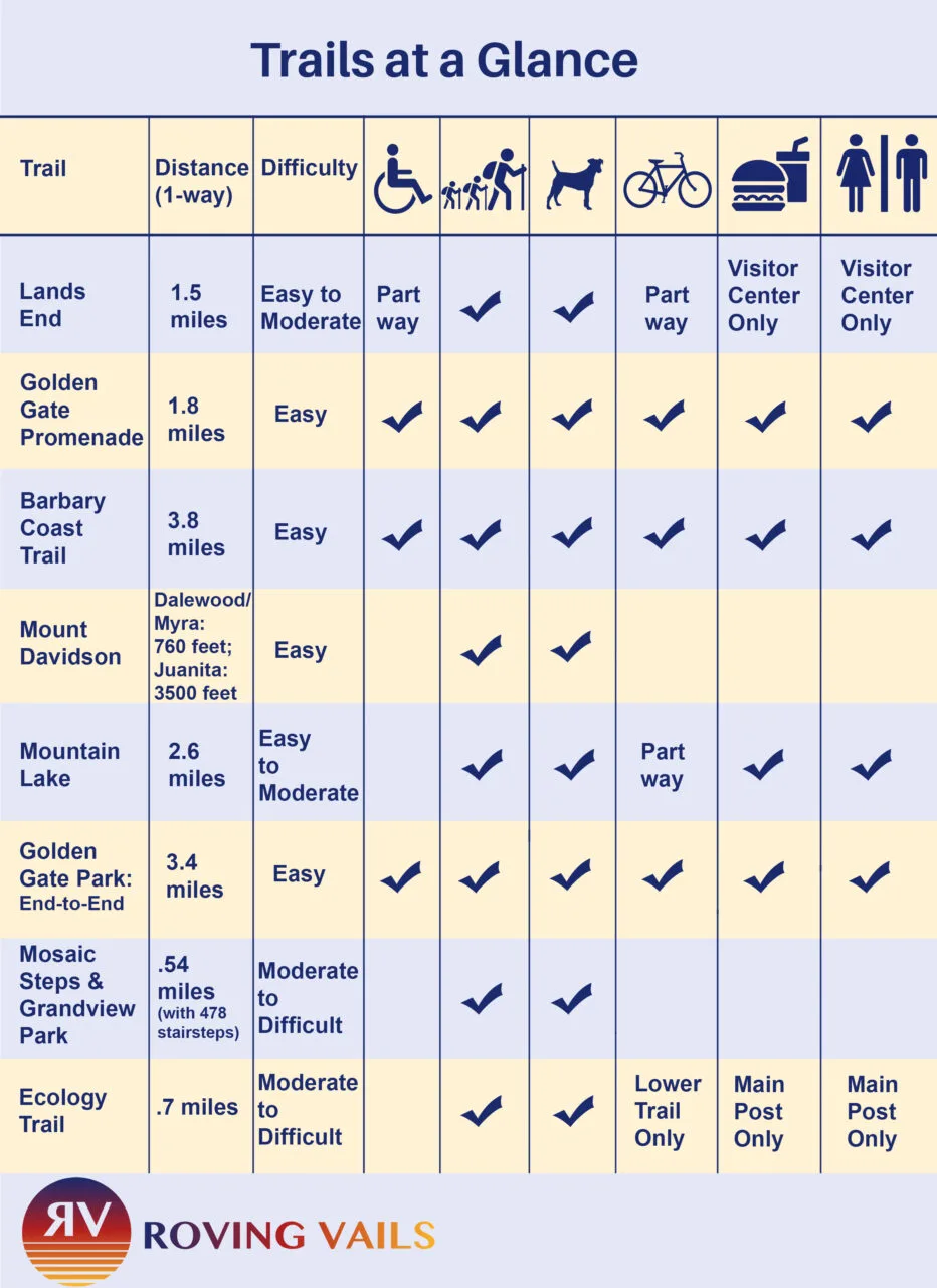
- Trails at a glance — a chart listing the trails and their features
- Map with trail locations and transit stops
- Best time to go
- Lands End Trail
- Golden Gate Promenade (through Crissy Field)
- Barbary Coast Trail (through the heart of the City)
- Mount Davidson
- Mountain Lake Trail (in the Presidio)
- Golden Gate Park Trail (from Stanyan to the Ocean)
- 16th Avenue Tiled Steps & Grandview Park
- Ecology Trail (in the Presidio)
Hiking in San Francisco

Map with Trail Locations and Transit Stops
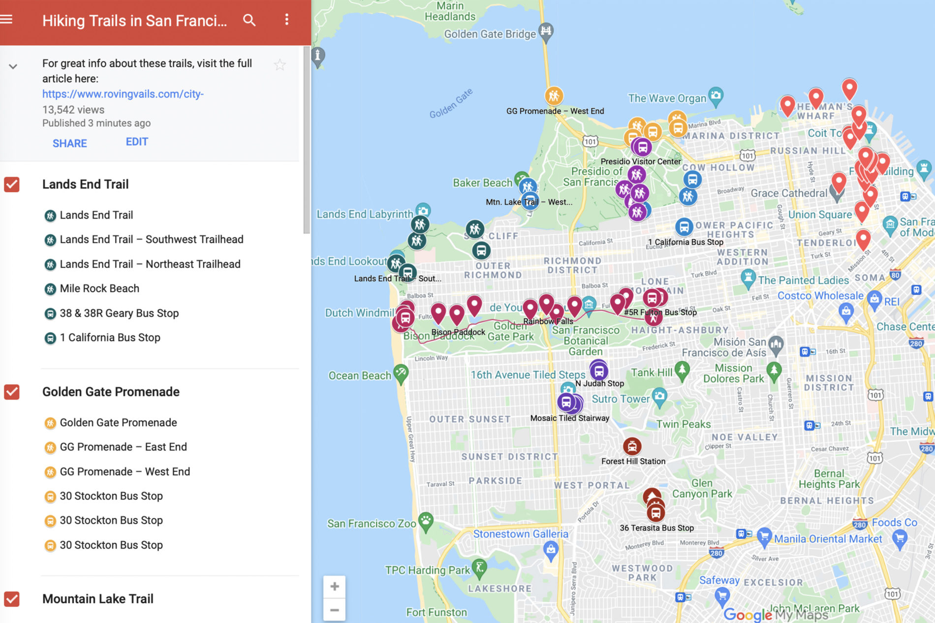

Getting to and from the Trails on Public Transit
There are lots things to do in San Francisco, and there’s lot of hiking options as well, but there’s not a lot of parking, so consider taking public transit. It’s easy; it’s inexpensive and many trails have public transit near both ends, making it convenient to hike a trail in one direction.
Best Time to Go
The weather is generally better in the spring and consistently best in the fall. If it’s rainy (winter), trails will be muddy and slippery, and if it’s foggy (summer) or rainy, the views won’t be great. Fortunately, there are nice sunny days scattered throughout the entire year.
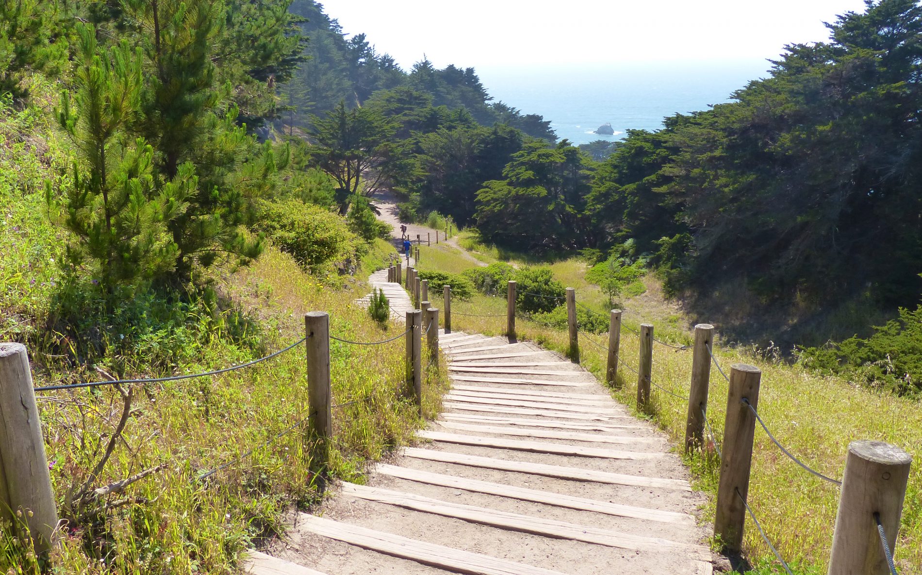

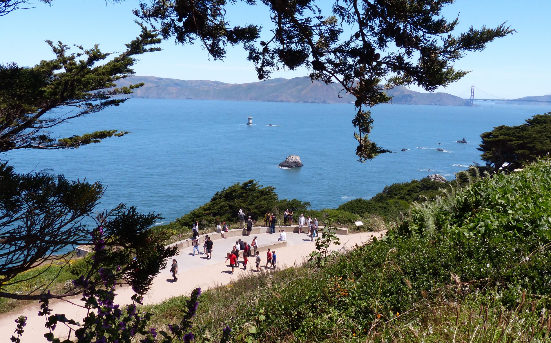
Lands End Trail
The Lands End Trail has spectacular views of the rugged Pacific Coastline (part of the PCH highway), the Golden Gate Bridge, windswept cypress trees, beaches, and wildflowers. Parts of the trail are along the coastal bluffs and parts wander through wooded areas. A short spur off the main Lands End Trail takes you to scenic Mile Rock Beach.
Lands End Trail at a Glance
| Distance (1-way) | 1.5 miles (2.4 km) |
| Difficulty | Easy to moderate |
| Accessible | Part way |
| Kids | Yes |
| Dogs (leashed) | Yes |
| Bikes | Part way |
| Food, water | Visitor Center only |
| Restrooms | Visitor Center only |
Location: Lincoln Park on the Pacific Ocean coastline in San Francisco:
Southwest Trailhead is at the Lands End Lookout Visitor Center (680 Point Lobos Avenue).
Northeast Trailhead is at 32nd Avenue and El Camino Del Mar (where El Camino Del Mar enters Lincoln Park).
Lands end is a great hike with beautiful views and an interesting history. Checkout our Lands End Hike post for greater detail about the trail, including the following:
- Lots more photos and a 2-minute video
- Getting to Lands End: parking and public transit for both the southwest and northeast trailheads
- Link to a Google map with the trail plotted and the trailheads and bus stops pinned
- Options for hiking the trail (one-way, round trip or shortcut)
- Trail conditions
- Spur trail to Mile Rock Beach
- Bits of Lands End history
- Lands End Lookout Visitor Center
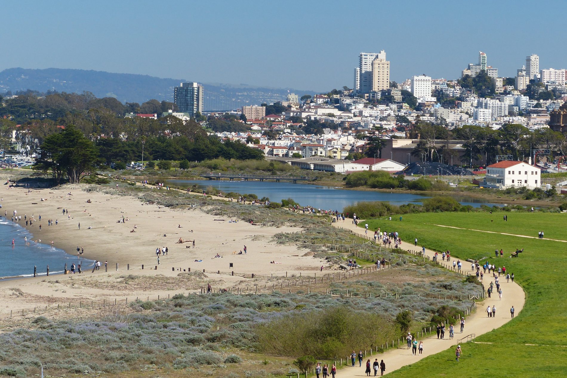

Golden Gate Promenade
The Golden Gate Promenade goes through Crissy Field in Presidio National Park. It’s on the edge of San Francisco Bay and has stunning views of the Golden Gate Bridge, the bay, the city skyline, and beaches. It also connects to the new Presidio Tunnel Tops attraction between the Presidio Main Post and Crissy Field.
The Promenade is wide and smooth enough to walk, jog, bike, or push a stroller. It’s also dog friendly and wheelchair accessible.
Golden Gate Promenade at a Glance
| Distance (1-way) | 1.8 miles (2.9 km) |
| Difficulty | Easy |
| Accessible | Yes |
| Kids | Yes |
| Dogs (leashed) | Yes |
| Bikes | Yes |
| Food, water | Yes |
| Restrooms | Yes |
Location: The trail follows the San Francisco Bay waterfront between Little Marina Green and Fort Point.
The Golden Gate Promenade is an awesome trail with stunning views in every direction. For a lot more detail about the trail, checkout our Golden Gate Promenade post, which includes the following:
- Lots of photos and a 35 second video
- Getting to Golden Gate Promenade: parking and public transit
- Link to a Google map with the trail plotted and bus stops pinned
- Points of interest (beaches, lagoon, birdwatching)
- Bits of history
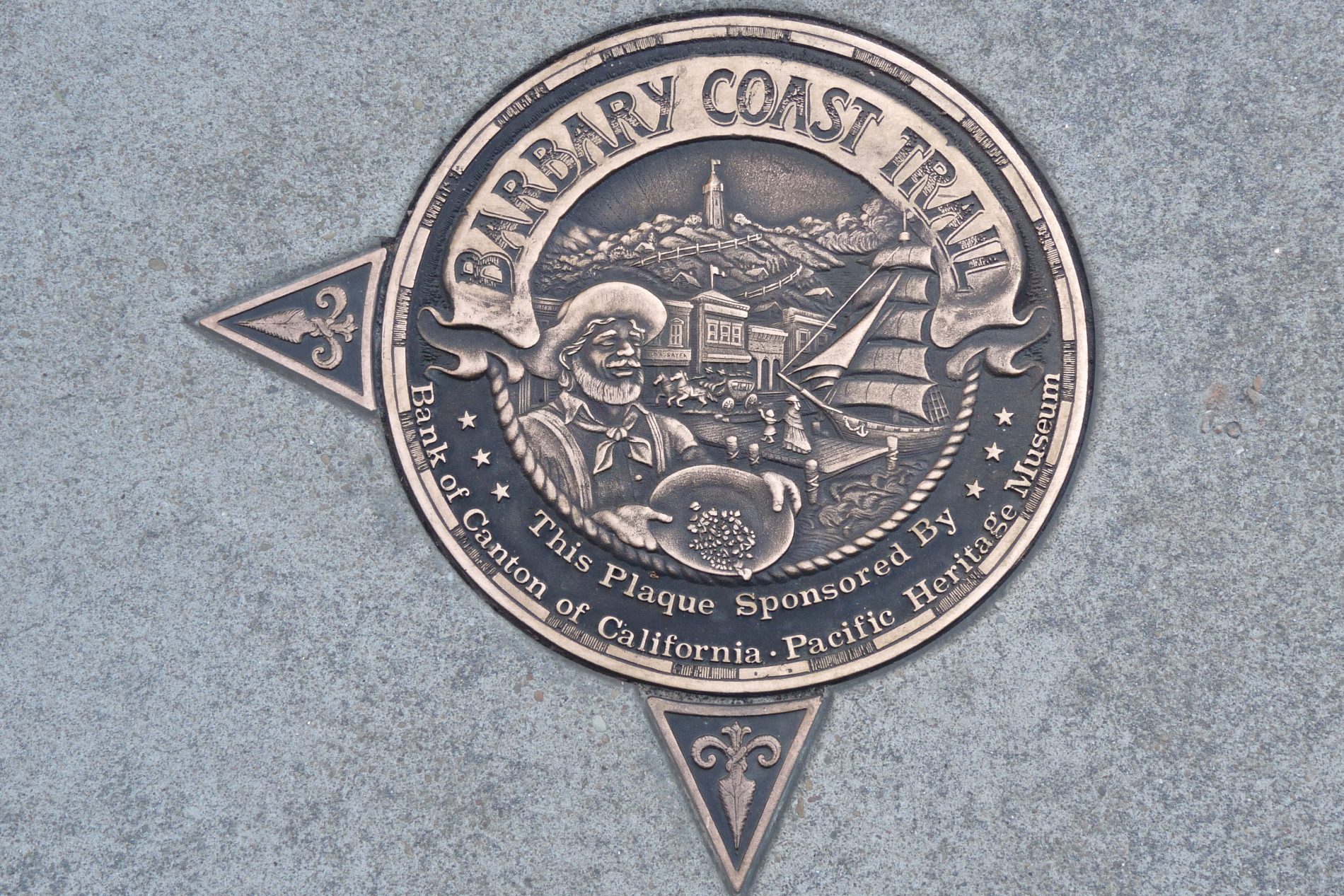

Barbary Coast Trail
The Barbary Coast Trail goes through the heart of San Francisco, and along the way, meanders through interesting neighborhoods with connections to historically significant events. The neighborhoods are Union Square, Chinatown, the original waterfront (Barbary Coast), North Beach, and the Wharf. These locations were influenced and shaped by the 1849 gold rush, the 1906 earthquake and fire, and wave upon wave of immigrants.
Barbary Coast Trail at a Glance
| Distance (1-way) | 3.8 miles (6.1 km) |
| Difficulty | Easy |
| Accessible | Yes |
| Kids | Yes |
| Dogs (leashed) | Yes |
| Bikes | Yes |
| Food, water | Yes |
| Restrooms | Yes |
Location: The main trail begins at the Old San Francisco Mint at 5th and Mission and ends in Aquatic Park by the Wharf.
There is so much to the Barbary Coast Trail that we’ve covered it in greater detail in our Barbary Coast, a self-guided walking tour. The full article has:
- Lots more photos
- Getting to the Barbary Coast Trail: parking and public transit
- Link to a Google map with the trail plotted and sites pinned
- Ways to take the trail (1-way or round trip via upper trail through Nob Hill)
- How 180 bronze medallions mark the trail
- Brief descriptions of points of interest along the trail
- Bits of history
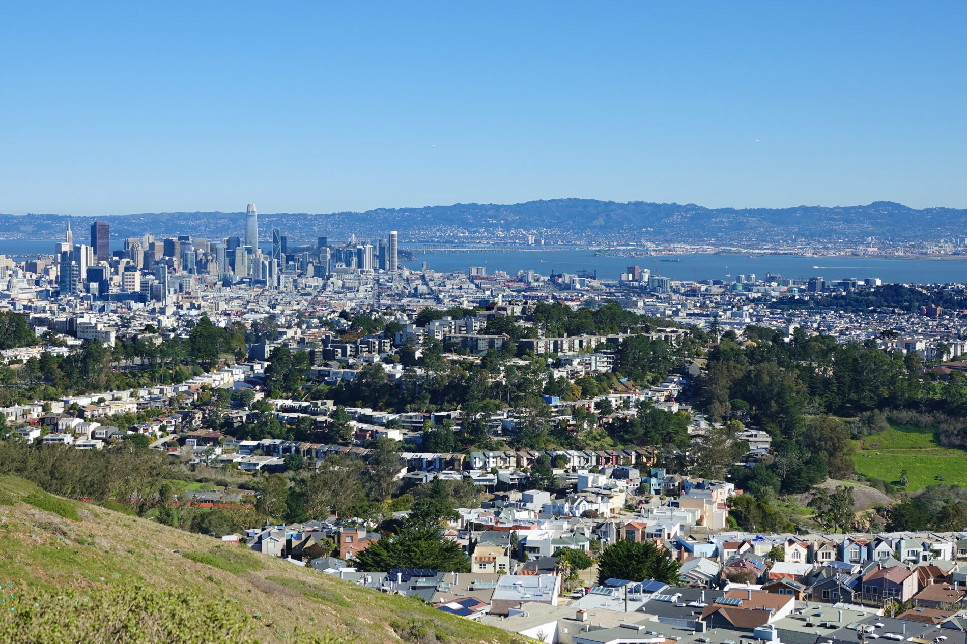

Mt. Davidson
Mt. Davidson is in the center of San Francisco and is the highest natural point in the city. It’s 938-feet high (286 m) and has sweeping views of the city and beyond. The trails leading to the top wander through tranquil cypress and eucalyptus wooded areas. There’s also a 103-foot (31.4 m) historic cross at the top with an interesting history.
Mt. Davidson at a Glance
| Dalewood/Myra Trail (1-way) | 760 feet (232 m) |
| Juanita Trail (1-way) | 3500 feet (1,067 m) |
| Both Trails (bus stop to bus stop) | Nearly 1 mile |
| Difficulty | Easy |
| Accessible | No |
| Kids | Yes |
| Dogs (leashed) | Yes |
| Bikes | No |
| Food, water | No |
| Restrooms | No |
Location: Mt. Davidson is in the middle of San Francisco. Here are the starting points for the two trails we recommend:
- The Dalewood/Myra Trail is on the southside of Mt. Davidson where Dalewood Way, Myra Way, and Lansdale Avenue come together. It’s next to a 36 Teresita bus stop.
- The Juanita Trail is on Mt. Davidson’s westside on Juanita Way. Follow Juanita Way in an easterly direction until you come to a flight of old stone steps. That’s where the trail begins.
We have a separate post dedicated to Mt. Davidson with a lot more detail, including:
- More photos
- Getting to Mt. Davidson: parking and public transit for both trails: Dalewood/Myra Trail and Juanita Trail
- Link to a Google map with the trails plotted and the trailheads and bus stops pinned
- Options for hiking the Trail (one-way, round trip)
- Weather and trail conditions
- Bits of history
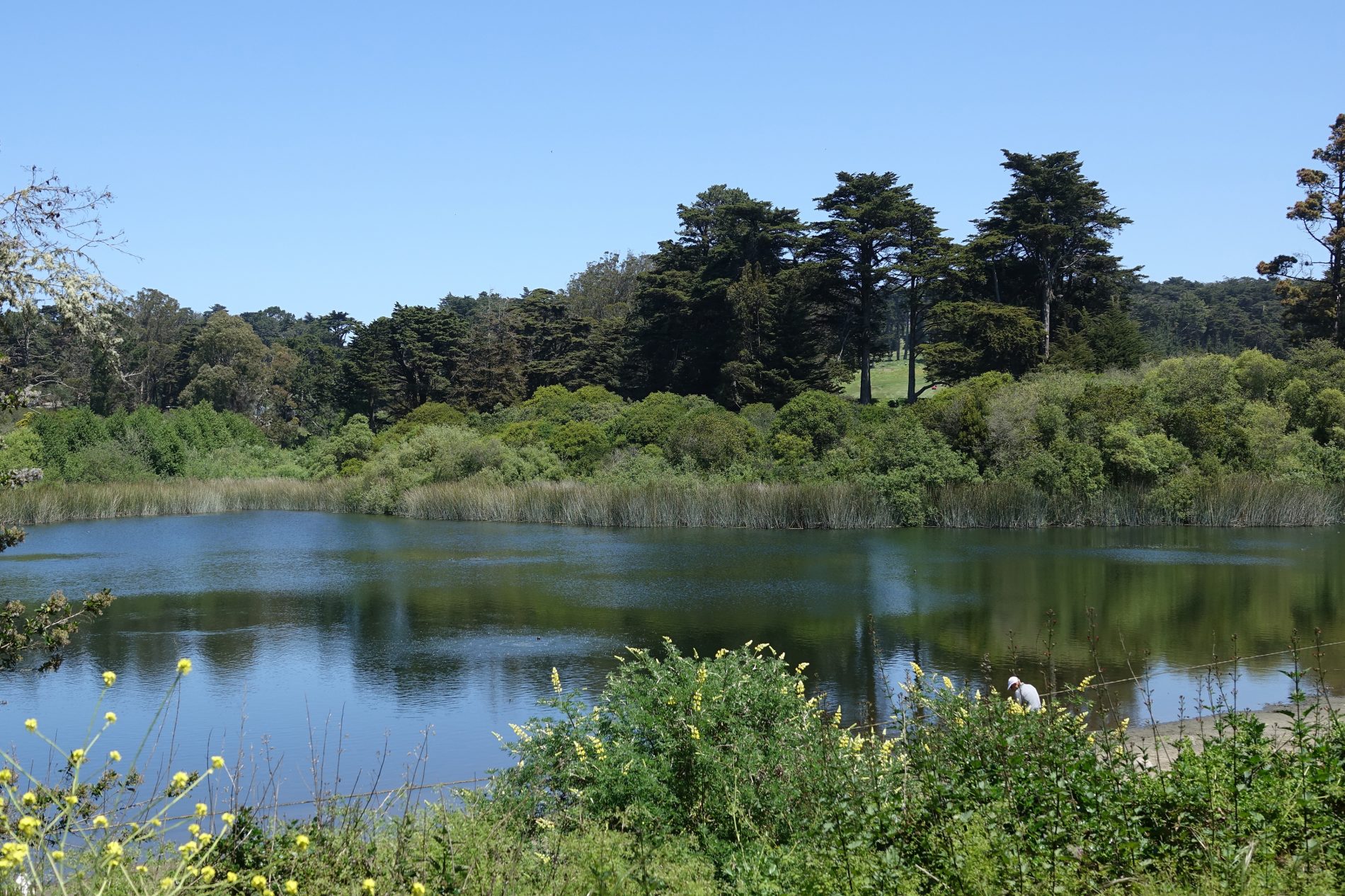
Mountain Lake Trail
Mountain Lake Trail is one of several trails in Presidio National Park, and it’s one of my favorites. The trail is mostly flat and easy to walk, and it deserves an A+ for the variety of interesting things to see along the way.
Going from the Presidio’s Broadway Gate to the Pacific Ocean, Mountain Lake Trail passes by or near these seven visit worthy sights: Lyon Street Steps, Wood Line Sculpture, Inspiration Point, an amazing garden at Presidio Wall Playground, Mountain Lake, a dune restoration project, and beautiful Baker Beach.
Mountain Lake Trail at a Glance
| Distance (1-way) | 2.6 miles (4.2 km) |
| Difficulty | Moderate |
| Accessible | No |
| Kids | Yes |
| Dogs (leashed) | Yes |
| Bikes | Part way |
| Food, water | Yes |
| Restrooms | Yes |
Location: on the southern edge of Presidio National park between Broadway Gate and Baker Beach.
Checkout our Mountain Lake Trail post for more information about the trail including:
- Several more photos
- Getting to the trail: parking and public transit
- Link to a Google map with the trail plotted and sights and transit stops pinned
- Brief descriptions of the seven visit worthy sights to explore along the trail
- Trail conditions
- Good things to know: food and restroom locations
- Bits of history

Golden Gate Park Trail from End-to-End
Golden Gate Park is a gorgeous place filled with gardens, lakes, meadows, woods, and even a small herd of bison. There are numerous paths winding around and through the park’s 1,017 acres (4 sq km) making it a great place for a walk, run, or bike ride.
The trail recommended here follows paved paths along either side of JFK Promenade and John F. Kennedy Drive. It winds through the full length of the park from Stanyan on the east end to the Great Highway and Pacific Ocean on the west end. Along the way, it passes through some of the parks most scenic areas and passes by several interesting sights.
JFK Promenade is the car free section of JFK Drive. There’s lots of room on the promenade, you can walk, run, skate, scooter, and bike on the car free roadway as well as the paths.
Golden Gate Park Trail at a Glance
| Distance (1-way) | 3.4 miles (5.5 km) |
| Difficulty | Easy |
| Accessible | Yes |
| Kids | Yes |
| Dogs (leashed) | Yes |
| Bikes | Yes |
| Food, water | Yes |
| Restrooms | Yes |
Location: Golden Gate Park is between San Francisco’s Sunset and Richmond districts. It’s 3-miles long and half-a-mile wide. The park is between Stanyan Street on the east end and the Great Highway and Pacific Ocean on the west end.
There is so much to the Golden Gate Park Trail that we’ve covered it in greater detail. The full article has:
- Lots more photos
- Link to a Google map with the trail plotted and places of interest pinned
- Link to the San Francisco Park Department’s downloadable park map showing the locations of points of interest, attractions, and amenities
- Getting to the Golden Gate Park Trail: Parking and Public Transit information
- Golden Gate Park’s free shuttle
- Points of interest along the trail
- Trail conditions, time needed, and weather
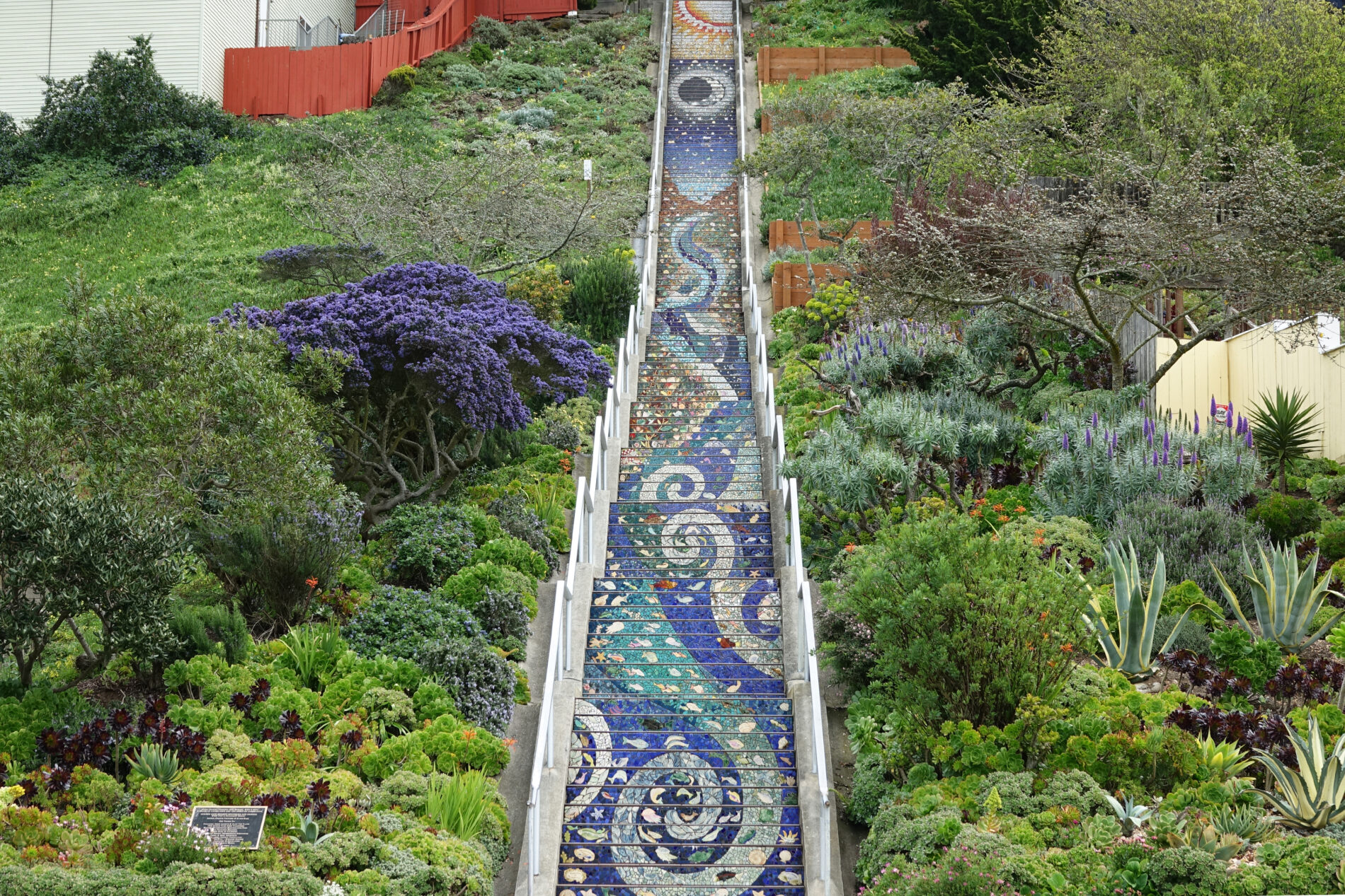

Mosaic Tiled Steps & Grandview Park
This is a unique hike because you will see and experience three great sights that happen to be really close together. There are two really long staircases that have been transformed into gorgeous works of art with the addition of mosaic tile murals. Then at the top of the hill, there’s a small park with amazing 360-degree views of San Francisco, the bay, and ocean beyond.
It’s a short hike, but it involves climbing a total of 478 stairsteps. The three sights are:
- 16th Avenue Tiled Steps
- Hidden Garden Steps
- Grandview Park
Tiled Steps & Grandview Park at a Glance:
| Distance (1-way) | 0.54 miles (0.86 km) |
| Difficulty | Moderate to Difficult (478 stairsteps) |
| Accessible | No |
| Kids | Yes |
| Dogs (leashed) | Yes |
| Bikes | No |
| Food, water | No |
| Restrooms | No |
Location: In the Inner Sunset District a bit south of Golden Gate Park. The Hidden Garden Steps begin at 16th Avenue and Kirkham Street. The 16th Avenue steps (Moraga Steps) begin at 16th Avenue and Moraga Street. Grandview Park is at the top of the hill above the 16th Avenue Steps.
We have a separate post dedicated to the Mosaic Steps and Grandview Park with more information, including:
- Lots more photos
- Link to a Google map with the trail plotted and places of interest pinned
- More information about the two mosaic stairways and Grandview Park
- Best time to go
- Parking and Public Transit information

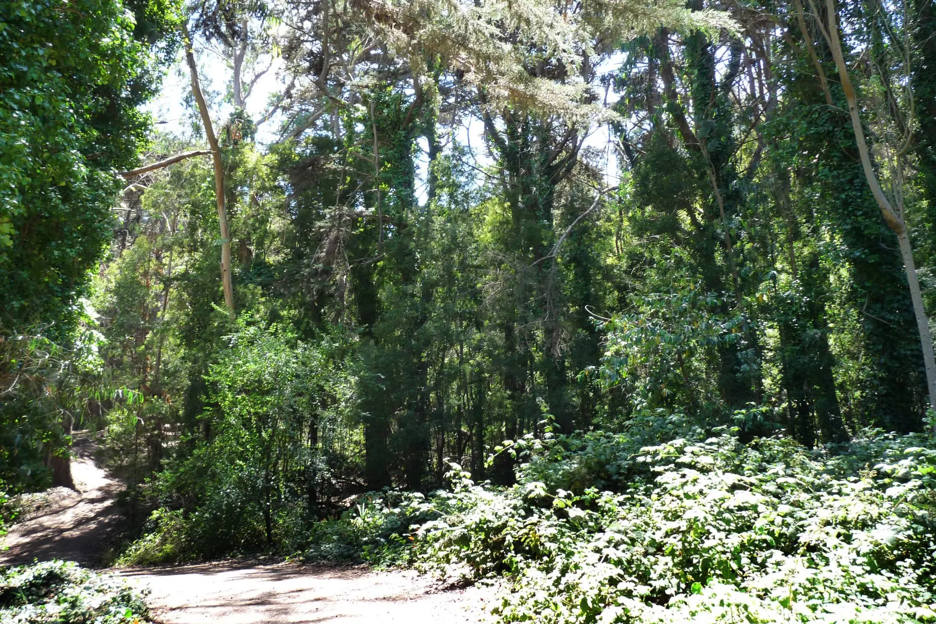
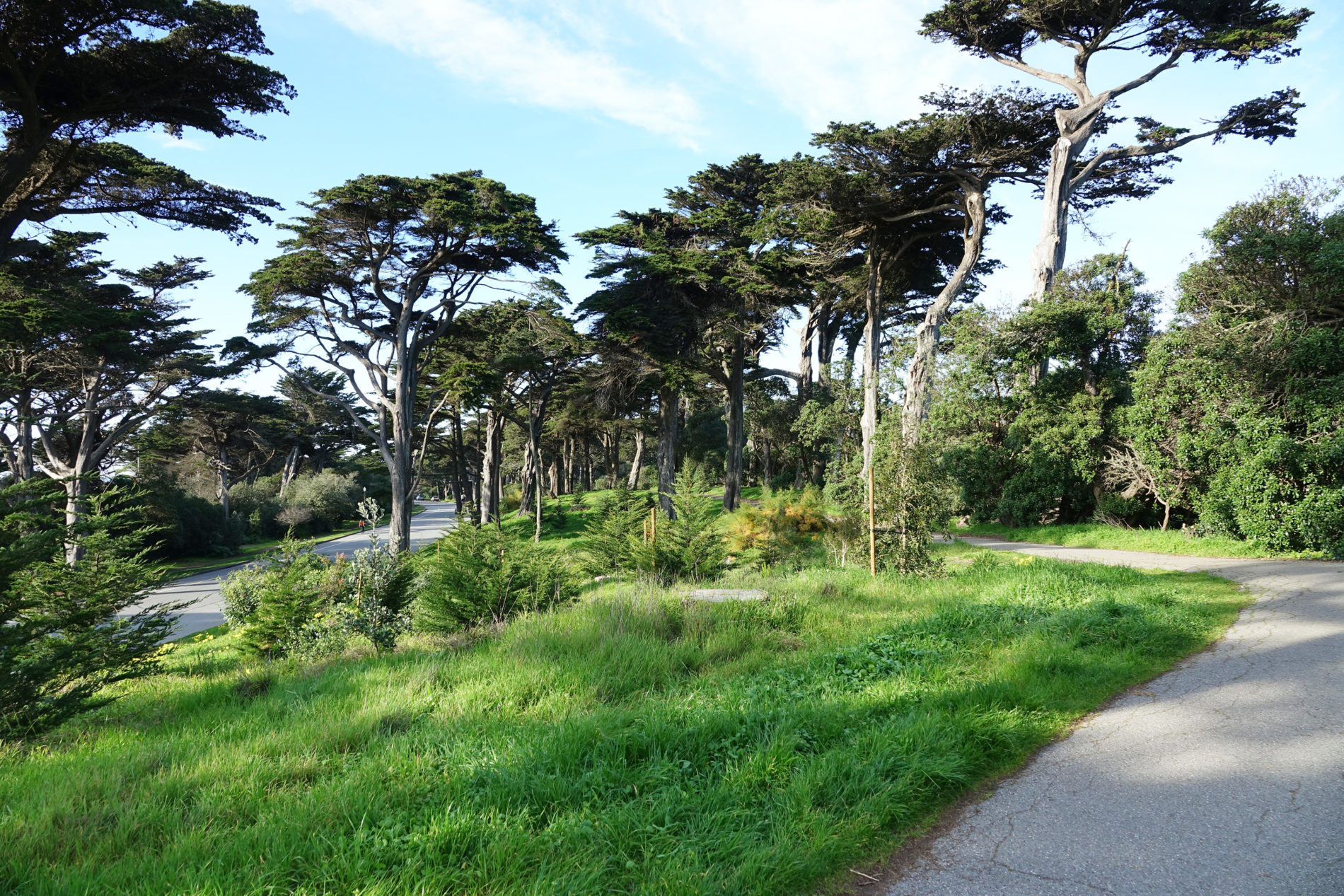
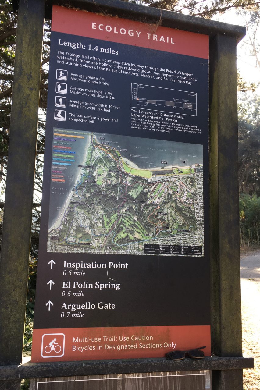
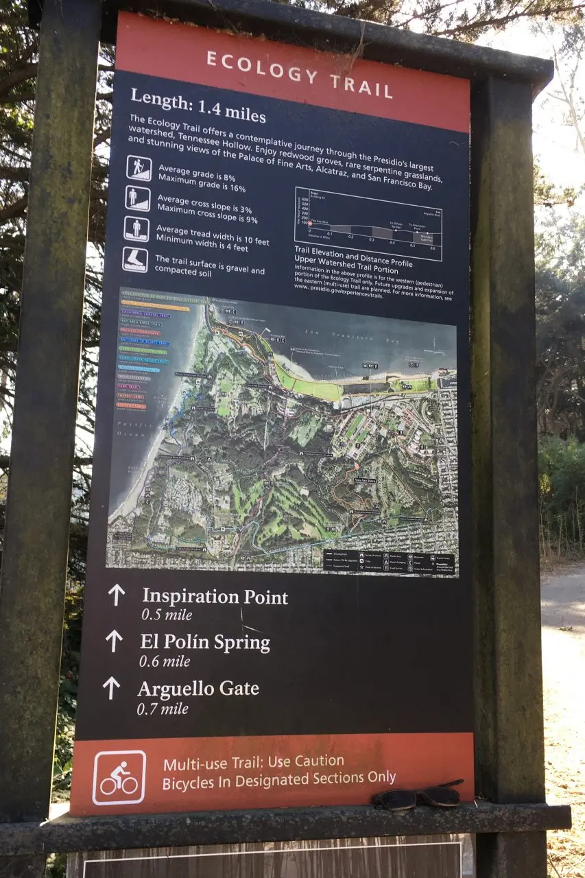
Ecology Trail
It’s called the Ecology Trail because it goes through a variety of habitats. It meanders through dense woods with eucalyptus, Monterey pine and cypress, and the largest redwood grove in the park.
Shortly before reaching Inspiration Point, the trail passes by Tennessee Hollow with serpentine grasslands and, in spring, a variety of native wildflowers like the endangered Presidio Clarkia.
Inspiration Point provides an expansive view of the Presidio and the bay beyond: including Alcatraz and Angel Island. It’s topped with a stone plaza and has lots of places to sit and take in the view.
Ecology Trail at a Glance
| Distance (1-way) | 0.7 miles (1.1 km) |
| Difficulty | Moderate to difficult |
| Accessible | No |
| Kids | Yes |
| Dogs (leashed) | Yes |
| Bikes | Lower trail only |
| Food, water | Main Post only |
| Restrooms | Main Post only |
Location: The trailhead is behind the Inn at the Presidio on the Main Post; is ends near Arguello Gate.
The trail is 1.4-miles (2.3 km) round trip. It’s wide and reasonably smooth but it is hilly, which explains the park’s moderate to difficult rating.
If the dense woods make you start to wonder if you’re lost, remember the trail is roughly parallel to and only about 400-feet from Arguello Blvd. You feel like you’re in the woods, but you’re never far from civilization.
The trail ends near Arguello Gate on the southern edge of the Presidio. Near the end, it passes by Inspiration Point. Climb the stairs up to the Plaza and take in the view.
You can return to the Main Post on the upper trial, or you can follow the signs toward El Polin Spring and pick up the lower Ecology Trail. The lower trail is not as well developed and signage is sparse, but it does turn the trek into a loop. The lower trail joins the upper trail near the Main Post end.
Getting to the Ecology Trail
Parking
- There’s a large parking lot on the main post by the parade ground and smaller lots scattered around the park. Most have time limits posted and some require payment. Check the signage and, if payment is required, look for a Pay-and-Display machine.
- There is also a small, free parking lot at Inspiration Point off of Arguello Blvd. It has 22 spaces and a 4-hour time limit.
Public Transit
On weekdays during non-commute hours, you can take the PresidiGo Downtown Shuttle between a stop near the SF Transit Center and the Presidio. It’s fast, comfortable and free. It isn’t currently running on weekends and it’s only available during commute hours to people who live and/or work in the Presidio.
The PresidiGo Downtown Shuttle is actually my favorite way to get to the Presidio Main Post during midday on weekdays. For stop locations and other details, get the PresidiGo route map and schedule.
The 43 Masonic Muni bus is the only Muni bus that goes to the Main Post in the Presidio. It loops through the Presidio and stops near the Visitors Center on its route between Fort Mason and Munich and Geneva. Here are two (of many possible) places you can catch a 43 Masonic Bus to the Presidio: 1) between the Fort Mason entrance and Lombard or along Lombard Street or 2) On Presidio Avenue at California. Both of these bus stops are pinned on the google map.
Conclusion
This post is an evolving bucket list of urban hiking trails in San Francisco. More trials will be added over time, but the eight trails included here now are great hikes. So pack up your Day Bag and take a hike.
About the Author
Ginny Vail is a travel writer who loves travel planning, sightseeing, photography, and videography. She’s visited all 50 states and traveled around the world. Her articles focus on discovering places to go, sights to see, and details about when and how to visit them.