The best views in San Francisco are on the Golden Gate Promenade, a great walk with gorgeous views of the Golden Gate Bridge, bay, and city skyline.
The Golden Gate Promenade is a great trail along the San Francisco Bay waterfront. There are gorgeous views in every direction, including the Golden Gate Bridge, San Francisco Bay, Crissy Field, and the San Francisco city skyline. The promenade also has beaches, picnic areas, fresh air, sunshine, exercise opportunities, and it’s free.
For more things to do in San Francisco, visit our San Francisco Itinerary article. It has 1, 2, and 3-Day Itineraries plus lists of suggestions for more things to see in San Francisco.
In This Article
This article has the following information about the Golden Gate Promenade:
- Location, time, distance, and difficulty
- Link to our Google map with pins marking the trail and bus stops
- Crissy Field Parking
- Getting to Crissy Field and the Promenade on Public Transit
- Crissy Field weather
- Points of Interest and Bits of History about sights along the trail
Location, Time, Distance, and Difficulty
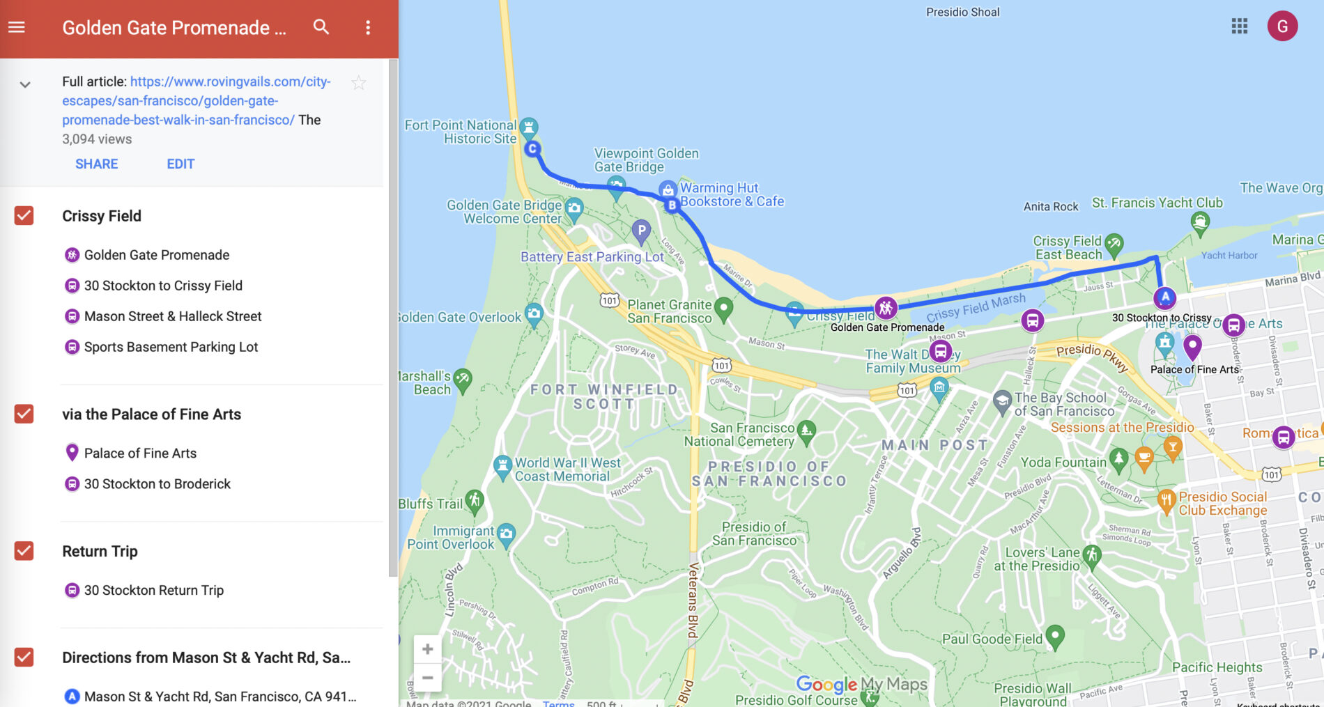
Located on the San Francisco Bay waterfront, the Golden Gate Promenade is between Baker Street, in the Marina District, and Fort Point, under the Golden Gate Bridge.
The Promenade is a very easy-to-walk trail. It’s wide, flat, and smooth enough to walk, jog, bike, or push a stroller. It’s also dog friendly and wheelchair accessible, and it’s all free.
| Distance (1-way) | 1.8 miles |
| Difficulty | Easy |
| Accessible | Yes |
| Kids | Yes |
| Dogs (leashed) | Yes |
| Bikes | Yes |
| Food, water | Yes |
| Restrooms | Yes |

Golden Gate Promenade Map

Crissy Field Parking
Here are four options for parking at or near the Golden Gate Promenade:
- Near Crissy Field Center and East Beach. The Crissy Beach lot is free and fairly big (about 300 spaces). The entrance is on Mason Street.
- West Bluff lot (next to the Warming Hut) is free on weekdays; fee on weekends
- Fort Point has a small, free lot
- Sports Basement lot on Mason Street is large and free

Getting to Crissy Field on Public Transit
Take the #30 Stockton bus toward either Crissy Field or Broderick. The #30 to Crissy Field makes 3 stops along Mason Street, which borders Crissy Field. The #30 Broderick bus ends after Broderick, so get off on Broderick and Jefferson, walk one block west to Baker (by the Palace of Fine Arts), then follow Baker to Little Marina Green and the waterfront trail.
Our Roving Vails article Getting around San Francisco on Public Transit provides more detailed instructions and information about:
- Fares and ways to pay
- Apps and maps
- Getting to Golden Gate Park and the Golden Gate Bridge
- Getting to the Palace of Fine Arts, Crissy Field, and Golden Gate Promenade

Crissy Field Weather — Be Prepared
One of the big attractions to the San Francisco Bay area is the weather. In the summer, when it’s 100+ degrees inland, it can easily be 30-40 degrees cooler in San Francisco. Even warm, sunny days in the city can get really chilly, really fast if/when the fog rolls in, so pack extra layers in your day bag..
Check out the Crissy Field webcams for realtime weather conditions for both Crissy Field and the Golden Gate Bridge.

Presidio National Park Trails Map
The National Park Service provides a really useful Presidio Trails Map on their website, which you can view on your phone and/or download as a PDF. In addition to the parks trails, the map shows locations of interest, including the Golden Gate Bridge and Welcome Center, historic Fort Point, Crissy Field, and the Warming Hut. (The Palace of Fine Arts is on the map too, although it’s not part of Presidio National Park.)
Bits of History and Points of Interest Along the Promenade
The 1.8-mile Promenade runs through Crissy Field between historic Fort Point, under the Golden Gate Bridge, and the Marina District, near the Palace of Fine Arts. Fort Point, Crissy Field, and the Promenade are all part or Presidio National Park.
The Presidio really is a National Park, and, if it were on any other continent, it would likely be a World Heritage site too.
Presidio National Park
Strategically positioned at the entrance to San Francisco Bay, the Presidio served as a military installation for 218 years. The Spanish built a garrison on the site in 1776.
After winning its independence from Spain, Mexico took control of the garrison in 1822. In 1846, the U.S. Army seized it from Mexico and occupied it until 1994. Now the 1,500-acre site, located inside the city limits of San Francisco, is Presidio National Park, which is one of the many things on our retirement bucket list.
In retrospect, it’s fortunate that the army occupied this 1500-acre site for 148 years. Otherwise, it would have become another San Francisco neighborhood completely covered with housing. And although the Army built more than 700 buildings, they built them in clusters keeping much of the acreage in its natural state.
The Presidio is operated by a Trust that manages the rehabilitation of the old Army buildings and then leases them as private businesses and residences. The Trust recycles the income back into the park to preserve its natural spaces and rehab more buildings. The Walt Disney Family Museum now occupies a former barracks building, and Lucasfilm’s Digital Arts Center was built on the site of the old Letterman Hospital complex.
Unlike most National Parks, there’s no entry fee. The park is free because it’s financially self-sufficient.

Fort Point
Just 3 years after seizing the garrison from Mexico, gold was discovered in California — the rush was on. People from around the country and around the world began streaming through the Golden Gate to get to the gold fields. The U.S. Army began building Fort Point to protect the entrance to San Francisco Bay.
The Army constructed the granite and brick fort between 1853 and 1861, just in time for the start of the Civil War. The point of land chosen for the fort was strategically perfect but elevation-wise, was way too high. The Army blasted the 90-foot (27 m) high cliff away until it was merely 15-feet (4.6 m) above sea level. This allowed the fort to be closer to water level making it possible to place artillery where cannonballs could skip over the water striking enemy ships at their waterline.
Even in the 1920s, when the golden Gate Bridge was being designed and engineered, Fort Point was considered so historically significant that rather than demolish it to accommodate the bridge’s southern footing, a special span was created so the bridge would arch over Fort Point.

Warming Hut Park Store and Café
The Warming Hut occupies a renovated former Army storehouse that was built in 1909. The Hut provides much-appreciated sandwiches, salads, soup, bakery items, hot and cold drinks, and, thankfully, restrooms. It also has a selection of gifts, gear, and locally made souvenirs. It’s near the west end of the Promenade by Torpedo Wharf.

NOAA Greater Farallones National Marine Sanctuary Visitor Center
The Greater Farallones National Marine Sanctuary is responsible for protecting 3,295 miles off the California Coast. Its tasks include research, conservation, education, and protection of sanctuary waters.
The Greater Farallones National Marine Sanctuary is part of the National Ocean Service (NOS), which is a branch of the National Oceanic and Atmospheric Administration (NOAA). The visitor center offers educational resources about wildlife and conservation. The picturesque building it occupies is a historic former Coast Guard station.

Crissy Field
In 1915, the Panama–Pacific International Exposition was held in San Francisco, and many of the structures built for the Expo were built on the dunes along the waterfront. It was a World’s Fair, which celebrated the completion of the Panama Canal and symbolized San Francisco’s recovery from the 1906 earthquake.
In World Wars I and II, the waterfront became the airfield for the Presidio Army base and was named Crissy Field. When the army left, it was a dilapidated, asphalt-covered mess.
It took nearly 20-years, $35 million, (mostly from private donations), and thousands of volunteers to transform Crissy Field from an abandoned airfield to a pristine wetland. It was the largest community project ever undertaken in San Francisco, but it was certainly worth the effort. Now Crissy Field has a tidal marsh, a grassy meadow, sand dunes, a beach, and picnic areas.

Crissy Marsh
The marsh was once a wetland and part of the Pacific Flyway for migrating birds. The restoration included adding a tidal lagoon to restore part of the marsh.

East Beach at Crissy Field
Crissy Field’s East Beach is very popular and is a favorite spot for children and dogs to play. It’s conveniently close to the Crissy Beach Parking Lot.
Crissy Field Center
Crissy Field Center has classes and programs for youth to “encourage new generations to become bold leaders for thriving parks, healthy communities, and a more environmentally just society.”

Palace of Fine Arts
The Palace of Fine Arts is not part of Presidio National Park. I’ve included it because you’re likely to walk past it or through it if you take the #30 bus to Broderick and Beach to get to the Promenade’s east end.
The Palace of Fine Arts was built for the 1915 Panama-Pacific International Exposition — A World’s Fair, which celebrated both the completion of the Panama Canal and San Francisco’s recovery from the 1906 earthquake. The faux Roman ruin is a very popular photo op, especially for wedding photos.

Conclusion
The Golden Gate Promenade, with its splendid views of the the Golden Gate Bridge, San Francisco Bay, and city skyline, has to be one of the best things to do in California. It’s an easy walk on a wide, smooth, flat surface, and it’s absolutely free.
Our Hiking in San Francisco post has brief details about our favorite hikes. We also have separate posts for each hike with a map, photos, and more detailed information:
- Lands End Trail: Ocean Views
- Barbary Coast Trail: Self-Guided Walking Tour
- Mt. Davidson: Scenic Trails, Sweeping Views
- Mountain Lake Trail: Presidio Hike
- Golden Gate Park: Trek from End-to-End
- Gorgeous Mosaic Tiled Stairs and Grandview Park Views
About the Author
Ginny Vail is a travel writer who loves travel planning, sightseeing, photography, and videography. She’s visited all 50 states and traveled around the world. Her articles focus on discovering places to go, sights to see, and details about when and how to visit them.


Dorene Campanile
Tuesday 17th of March 2020
I would like to know what happened to the Bricks that were installed in the Promenade at the Golden Gate Bridge. My husband had a Brick place there in December 19, 1988. It was Brick # 101588, the inscription. read:
JOHN B CAMPANILE
Location of the Brick was P92. The last time we were there all of the Bricks were gone?
Corinne Vail
Thursday 19th of March 2020
This 1987 article explains why the bricks were removed and states that a memory wall will be added to replace them. I’ve not seen the memory wall but will look for it next time I’m there. https://www.sfgate.com/bayarea/article/1987-Golden-Gate-Bridge-bricks-soon-just-a-memory-2596082.php
DONNA WADDLE
Wednesday 30th of October 2019
Hi I bought a brick in memory of my Dad. It was placed there with the others. I know they dug them up. How can I get information on where they are now?
Ginny Vail
Monday 4th of November 2019
Donna, I'm so sorry this happened to you and so many others. This 1987 article explains why the bricks were removed and states that a memory wall will be added to replace them. I've not seen the memory wall but will look for it next time I'm there. https://www.sfgate.com/bayarea/article/1987-Golden-Gate-Bridge-bricks-soon-just-a-memory-2596082.php